Travel itinerary app. Choosing the best navigator for pedestrians. Travel app
Travel apps, which will help the tourist to book tickets, choose seats on the plane, buy profitable tours, see the sights and find the right points on the map. Any month of the year is suitable for traveling to a new country, and mobile applications for tourists will come in handy.
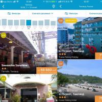
Travelata
Travelata- a new mobile travel application from the hypermarket of tours. Not a single travel agency will offer you last-minute tours for 5000-10000 rubles, but they really are. Such tours are found and booked online! While you go to the travel agency, someone will book your tour online. In the application for tourists, search for 120 tour operators, you can find really low prices, cheaper than buying air tickets. There are filters by price, number of stars, food, etc. All documents are processed online, you receive notifications by mail. With the Travelata application, you do not have to overpay for the services of travel agents.

Level Travel
Level.Travel is one application instead of 100 travel agents. Here you can find profitable tours, in the search they are always shown first. There are tours with an "instant confirmation" option, which means that they will be booked immediately. You can choose the budget, the star rating of the hotel, the type of food, even the distance from the sea. Also Level.Travel has introduced a system of bonuses with which it is even more profitable to travel. For each purchase you get points with which you can pay for tours in the future. For the first booked tour you get 2% points, for the next 1% of the tour cost.
Branded travellink cards
Another new travel app. Offline maps, which indicate attractions, hotels, cafes, stops, ATMs. Maps work completely offline, Internet is not needed! They plot a route, show sights nearby, exchange rates and interesting places.
Aviasales
Aviasales includes top useful travel apps. The beauty of the app for tourists is that it can help you find and buy tickets for air travel at the lowest price. The application is multifunctional and contains a lot of useful information. Tickets from over 700 airlines are available for purchase in one app. Regular, charters, low-cost airlines - everything is here. It was also Aviasales that was the first to introduce the function of choosing air tickets without luggage. The mobile application for tourists can be downloaded from the App Store, Google Play and Windows Phone. Installation links:
Hotellook
Hotellok is the best app for travel and tourism. With it, you can choose and book a hotel anywhere in the world. The application for tourists allows you to compare prices for rooms on different sites. There are many filters and a handy hotel map. Moreover, you can book a room not only on well-known sites, but even with tour operators who sell pre-purchased hotel rooms.
Tripinsurance
Tripinsurance is a new application for tourists who care about their health. Here you can view your insurance for traveling abroad and buy it at a discount, get a doctor's consultation online, call the insurance for free through the application, write to chat or email.

BlaBlaCar
BlaBlaCar is a useful travel app that every traveler needs, especially those on a budget. It offers services to find fellow travelers anywhere. Allows travelers to reach their destination at a small price, as well as save on gasoline for drivers.
TouristEye
Convenient mobile travel app TouristEye. This service specializes in travel planning. This is your personal guide to any city and country in the world. You no longer need to book someone's hiking trips, but you can choose what you want to see, plan the time and all the details yourself.
Couchsurfing
Couchsurfing is another sensational mobile application for tourists, the essence of which is to find free accommodation for the traveler. Ranked among the world's top travel apps. You just need to register and fill out the required form. But it is worth considering that each tourist has his own rating, which affects whether you will be invited to their place or not.
WikiRoutes
WikiRoutes is one of the best travel apps. This is an online guide to transport around the world. Very convenient for traveling around Russia. All route options are indicated on the map, stops, fares. You can be absolutely sure of the honesty of this application, because the users themselves edit this directory. The prospect of getting lost in an unfamiliar city does not threaten the owners of such a mobile travel application.

CoPilot GPS
CoPilot GPS is an offline application for tourist drivers that plots the best routes for a trip. The useful travel app is well-optimized and supports real-time road quality information.
MAPS.ME
Maps Me— mobile application for travel, detailed and fast maps of the whole world. Absolutely everything - from a giant city to a small inconspicuous village. And most importantly, the application provides all this information offline. For the map to work, you need to download this area to your phone, and that's it. The location is determined by satellite. The map lays routes without the Internet. You can mark your interesting places.
HERE
HERE is another useful travel app that gets you directions. Allows the user to choose the best route. Suitable for any type of transport.
Free wifi finder
Free wifi finder is one of the top travel apps. With this application, everything is extremely simple and clear: it searches for the nearest wi-fi distribution points, which allows the traveler not to waste Internet traffic.
Google translate
Google translate- the famous best application for traveling around the world from the famous American corporation. It translates anything from any language to any language. Useful for travelers in overcoming the language barrier in any country.
SeatGuru
SeatGuru is a mobile travel application with which you can find out information regarding your aircraft: flight status and its number. Also in the application is available a map of the cabin, which marked the most comfortable seats.
GateGuru
GateGuru- this mobile travel application shows all the information regarding the airport. It will allow you not to get lost and shows places where you can spend time while waiting for a flight.
Redigo
Redigo is another useful travel app, an offline travel guide and guide with maps for all countries available for download.
TripAdvisor City Guides
Tripadvisor is a series of mobile guides where users leave all the information: from choosing the best tickets to recommending a hotel. It is most useful if you are visiting a place for the first time and do not want to get lost or make the wrong choice.
food spotting
food spotting is a social mobile travel application that specializes in the selection and search of places to eat. Cafes, bars, restaurants - reviews of any institution in one application.
XE Currency
XE Currency– a mobile travel application monitors changes in the currency exchange and provides them to the user. Very convenient for people who keep their savings in other currencies. The application is able to work offline, as it saves all the information during the last access to the Internet.
Pin Drop
Pin Drop is a compass app that shows you the way to any bar in the world. You can mark your favorite places in it. So if you don't know where you want to spend the evening - just take a look at the map
flight radar
Many people know the computer version of this program. But there is also a mobile application flight radar for travel, able to track the flight route of any civil aircraft. The owner of this application is able to check his coordinates right during the flight.
trip it
trip it- an indispensable assistant for those who travel for a long time. The application for tourists allows you to plan a vacation or any other trip. The data is saved and at the right time the application will ask you to confirm your hotel or flight booking.
Now you know about the best mobile applications for tourists. All these travel apps will make your life and holidays in another country much easier. So do not postpone such adventures on the back burner. The world is too big and beautiful to waste time in one place. And if you have long been comforting yourself with excuses that organizing a trip costs a lot of work, then everything is easier than you think! Travel and explore.
Not everyone needs a full-fledged car navigator with a countless set of often unclaimed features. Sometimes there is a need for the simplest and easiest voice navigation application that will simply allow a hiker or traveler to find their way to their starting point.
So, we bring to your attention an excellent application "I'm going home", which is simply obliged to settle in the smartphones of mushroom pickers, hunters, scouts, hikers and other people who often find themselves in forests or on unfamiliar rough terrain. Now you can be sure that you will never get lost.
You must understand that the main task of this navigator is to lead you to the starting point. The program is very simple, but copes with its purpose with a bang. There are no maps, compasses, sensors. The main possibility is to correct the direction of movement of the smartphone owner to the starting point with the help of voice prompts. At the same time, you must understand that the application will not guide you along the reverse route, but along the shortest path to the house (starting point). Therefore, if you saw a quagmire or cliff in front of you when returning, go around them. The program will not replace your eyes, but after rounding the obstacle, it will again continue to lead you to the house in a straight line, adjusting the route. If necessary, you can use Google Maps - the application is compatible with them.
Price: Free
OPERATING PROCEDURE
The algorithm for working with the navigator looks something like this:
1. Launch the application
2. Turn on GPS
3. We are waiting for the coordinates of your location at the moment (displayed in a gray box) - these will be the coordinates for the return
4. Press the menu button on the phone and select "Record" from the menu that appears
5. Next, you will be asked to write down the coordinates in the form of a word: for example, "Camp". After that, click "Record and select."
6. That's it, now that the coordinates of the conditional "home" are entered into the smartphone, you can turn off the program or even the smartphone itself. Then, when you need to find the way to the "home", just launch the navigator and press the green "Let's go home" button.
It is clear that you can drive a lot of such conditional "houses" into the program and then simply choose the right one from them.

As you can see, "I'm going home" is an ideal navigator for mushroom pickers, berry pickers, hunters and hikers in its simplicity and necessary capabilities, which will not let you get lost. The program works on devices with Android version 2.1 and higher and support for GPS navigation.
Installing the program is simple. Download the installation file with the .apk extension, upload it to your smartphone and start installing the application.
The times when special devices were used for navigation are long gone, and now any Android device, be it a smartphone or tablet, can perform the functions of a GPS navigator. Thanks to this, the navigator of a modern person is always at hand, which is especially convenient for walking in unfamiliar areas.
There are a huge number of applications for navigation on Android, and choosing something for yourself may not be such an easy task, especially if you have not seriously used the navigator before. In this guide, we will look at some of the best navigators for Android that can be fully used both in the car and on foot.
Page navigation:
You should start with what is more affordable. Google Maps has established itself not only as functional interactive maps, but also as an excellent navigator that can be used by the driver and pedestrian.
Advantages of Google Maps:
- High-quality navigation in 220 countries and regions (15 thousand cities);
- Voice navigation support for drivers and pedestrians;
- Ability to view information about traffic jams, as well as search for a faster alternative route;
- Providing up-to-date information about places and organizations on the map;
- Ability to overlay satellite photos on the map;
- 3D models of some buildings and sights on the map;
- Street View in Live View.
It should be noted that for a free application, Google's navigator includes a solid set of functions (for example, viewing traffic jams), which is often provided to users only for a separate fee.
 If you need a navigator that can work safely offline, be sure to check out MAPS.ME.
In general, an excellent navigator for long-distance travel. Recommended primarily for offline use.
Advantages of MAPS.ME:
- High-quality navigation for a pedestrian;
- The application is based on the OpenStreetMap project, which supports many users around the world by regularly uploading new photos of attractions and updating route information;
- Possibility of preliminary loading of topographic data of the required area;
- Thanks to good optimization and data compression technology, this navigator can be called one of the fastest;
- Great interface.
Locus
 According to many users, Locus is the best navigation app for Android because it gives you access to features that other similar apps don't have.
Advantages of Locus:
- Navigation for a pedestrian, biker, motorist;
- Ability to work online or offline;
- User-friendly interface that can be customized according to your preferences;
- Special augmented reality mode.
The application can be downloaded in one of two options, paid or free. If you use the free version, then ads will appear on the screen from time to time. In addition, this version does not contain some features (for example, augmented reality).
 After Yandex had its own service for mapping, over time it acquired many features, including GPS navigation. However, navigation is only available in Russia and neighboring Ukraine.
Advantages of Yandex.Navigator:
- Convenient navigation for both motorists and pedestrians.
- Small distribution weight. The downloaded apk weighs only 12 MB (however, it should be noted that the application loads maps in the "online" mode, which makes it impossible to work without the Internet);
- Providing the most up-to-date information about the terrain and roads in Russia;
- Convenient and uncomplicated interface. Even the one who uses the navigator for the first time will understand;
- View traffic jams in real time.
If you are not worried about the excessive consumption of Internet traffic by the application, then this navigator will be an excellent choice for traveling around Russian cities.
Going on a long trip by car, you may encounter many different inconveniences and problems. To make your journey easy and enjoyable, we have selected and tested the most useful mobile apps on the road. It turns out that using a smartphone, you can find the nearest hotel or organize a free overnight stay, calculate fuel costs or call for technical assistance at the touch of a button, and even get a virtual navigator. Already packing your bags and filling up a full tank of gas? Then this review is for you!
A handy app for planning your itinerary. Especially if you do not know the road or city, then Maps.Me will help you. It works very simply: download the maps of the countries you need, set the route, and you're done! Works without internet access. This means that at any time you can look at the saved route and travel without fear of missing the desired turn.


Name: Maps.Me
Price: For free
Compatibility: Universal Application
Link: Install
Copilot
The application allows you to download maps of 38 countries of the world that are available without access to the Internet. The maps show bright sights with links to Wikipedia, by clicking on which you can find out, for example, the history of some cultural monument or an ancient building.


Name: Copilot
Price: For free
Compatibility: Universal Application
Link: Install
Couchsurfing
This is a social network for those who are used to traveling light. Members of the network provide each other with free assistance and accommodation during travel or organize joint trips. If you can’t afford or don’t like the option of booking a hotel room, take advantage of the offers of couchsurfers. Just choose the country and city you are going to visit, and the application will give you hundreds of ads of real people with an offer to stay with them.


Name: Couchsurfing
Price: For free
Compatibility: For iPhone
Link: Install
Russian AutoMotoClub (RAMK)
The application is simply indispensable when traveling around Russia and Europe. If a malfunction occurs on the way, technical assistance can be called in 30 seconds with one button. The coordinates of your location will be determined automatically by GPS. Operators working around the clock will promptly contact you and send you a tow truck or technical assistance vehicle. It is also possible to get a free telephone consultation from experienced car mechanics. Currently, the company provides services in 400 cities throughout Russia and Europe. All of the above services will be free of charge for members of the RAMK Auto Club. Also, an extensive database of official dealerships is loaded into the application.


Name: Russian AutoMotoClub
Price: For free
Compatibility: For iPhone
Link: Install
City Maps 2Go
Must have for every traveler. Download maps, choose a city and go! Hungry? Select in the "food" tab, and the application will show on the map all the restaurants located nearby. The same with cafes, shops, banks and other places of recreation. Bookmark the object, or attach a sticker to the map. For convenience, cafes can be marked with one color, banks with another, and shops with a third, so that later you know where to go to eat or exchange money. There is no navigation, but it is very easy to navigate.


Name: City Maps 2Go
Price: For free
Compatibility: Universal Application
Link: Install
Redigo
What can be transported through customs? How profitable is it to change the currency? What current events are taking place in the country? You can easily find answers to these and many other important questions in the Redigo app. Choose the country where you are going to go, download information to your phone and get free access to information without any Internet. The application also contains travel guides, maps and a phrase book in 6 foreign languages.


Name: Redigo
Price: For free
Compatibility: For iPhone
Link: Install
Second Pilot
The application was created in order to warn drivers on the way. When you drive in an unfamiliar area, you don’t know where an “ambush” will be waiting for you. Here you will come to the aid of other motorists who have discovered the ill-fated pits, speed bumps or insidious speed cameras. The application has voice prompts, which means that you do not need to constantly look at the screen. Also, the application monitors the speed and reports the excess. When traveling in Russia, that's it!


Name: Second Pilot
Price: For free
Compatibility: For iPhone
Link: Install
MultiGO Fuel
The MultiGO Fuel application contains a database of gas stations with prices, reviews and ratings, which is updated every day. The driver can set any filters convenient for him: by type of fuel, by brand of gas station, by type of accepted fuel cards, and so on. In addition, the application will allow you to personally participate in price monitoring.


Name: MultiGO Fuel
Price: For free
Compatibility: For iPhone
Link: Install
Find Your Car with AR
If you parked your car in the alleys of an unfamiliar city and set out to explore the neighborhood on foot, the app will help you find your way back to your car. The application determines and remembers the coordinates of the location of the machine. It is enough to activate the application and go about your business. And when needed, the application itself will find your car and show you the way, wherever you are!


Name: Find Your Car with AR
Price: For free
Compatibility: Universal Application
Link: Install
Car Camera DVR
Recently, the DVR has become popular with motorists. Very handy, such a gadget will be on a road trip. The DVR will help not only to record the moment of the accident, but also to capture beautiful landscapes along the way, which you can then show to your friends. Now there is no need to buy a separate DVR, you can just download the application to your phone! DVR Car Camera DVR is shooting in HD-quality. The application allows you to turn off the screen completely when recording, or display only the most necessary information on it, such as the current speed, time and direction of movement. 
Name: Car Camera DVR
Price: For free
Compatibility: For iPhone
Link: Install
Hudway - Navigator for night driving
This application is designed specifically for those auto travelers who are more comfortable traveling at night. An ordinary navigator blinds and distracts attention at night, and Hudway is designed so that you can see your route on the windshield of a car. To do this, you need to add brightness to the phone, put it on the dashboard, and the picture will be reflected in the windshield. The voice assistant of the application will warn not only about road junctions, but also about dangerous bends or turns. The navigator is what you need, but we would not recommend relying on him alone!


Name: Hudway
Price: For free
Compatibility: For iPhone
Link:
Mandatory!
The problem of turning a smartphone into a hiking GPS navigator has been solved. The main navigator is now a smartphone, in terms of functionality and ease of use, it leaves far behind all existing special hiking GPS navigators. And in terms of reliability, sensitivity and battery life, it caught up with them.
I must say, it was not me who solved the problem, but the manufacturers of smartphones, batteries and software. I only selected worthy candidates and tested them in practice. I will not build secrets, I will gladly share detailed recipes, use and continue experiments.
First about the software.
There are dozens of programs that turn a smartphone into a navigator. The choice according to my requirements left only one program: Locus Map (Locus Map). It was written only for Android, so the choice of smartphones has narrowed significantly. There is a free, slightly cropped version of Locus Free, the full version of Locus PRO costs $ 8 one-time, I advise you to install it right away, because when you upgrade Free to Pro, you will have to do all the settings again, and there are a lot of them.
So, the main advantages of Locus, because of which it was out of competition:
- Availability of high-quality free offline vector maps of the whole world based on OSM (Open Street Maps). Here is a link to one of the . There are terabytes of regularly updated maps.
- The program understands raster maps, which are easy to make yourself from scanned paper maps. For example, using the Mapc2Mapc program. The beloved General Staff will easily take root here. Here is a map of the Crimea and the Lycian Way in Turkey made by me as a gift for you. Instructions for using the Mapc2Mapc program can be found below.
- Ease of recording track and waypoints. You can draw the track manually, put waypoints anywhere, not just at the current location.
- It is convenient to upload your tracks and points. Both of them can be placed in an unlimited number of folders, enabled / disabled by folders, or individually.
- There is no limit on the number of points, tracks and points in tracks.
- The ability to turn off auto-lock of the display (the display will still turn off to save energy) and assign functions to the volume keys, such as zooming. In practice, this means that the navigator can be controlled without tapping the screen. Actual and when the screen is wet, it reacts incorrectly to gestures.
- The location of directories with maps on the SD card is possible.
- Absolutely everything is configured: the type and size of the cursor, its position (in the center or ¼ of the screen), the color and width of the tracks, the size of the point icons, the options for displaying the names of the points (permanently, open by tap or when approaching) ...
- Unlimited customizable trip computers: amount of data, layout, font (size, transparency and color) - in any combination.
- Fine-tuning the recording of track points by time, distance and accuracy. This allows you to record only the points of real movements, and not wandering around the bush and jumping hundreds of meters in case of poor communication with satellites.
- Setting the use of the internal compass and barometer: filtration depth, on and off limits.
- Setting to turn off the GPS receiver to save power (always on, always off, only on when in use)
- Customization of all buttons of the top and two sidebars, auto-hide.
- Run the application as a service, which eliminates crashes when other applications are running at the same time (calls, photos ...). For example, for me, the track recording pauses when making calls, if not included as a service.
- The program is developing and constantly improving, new convenient functions appear, bugs are fixed when working on new smartphones and versions of Android.
True, the list is more than? I just wrote down what I'm interested in. The possibilities of the program are simply incredible, the developers are trying to create the most universal application based on GPS. Due to the huge number of settings, dealing with them is not easy. I will describe how to make the most necessary for the trip.
This is how the program window with the vector map of Crimea looks like for me. The difference from what is by default is only in the buttons at the top, on the side and in the trip computer.
Set up Locus.
1. Select all default directories- in the phone's memory, Not on an external SD card. This is done in settings. Directories for vector maps locus/mapsVector and raster locus/maps can also be placed on an external SD card by specifying this in the program settings.
2. Download a map of the area where you are so that you have something to work with.
Copy vector maps (in .map format) to locus/mapsVector, and raster maps to locus/maps. If you took a vector map from the link above, then they have their own styles, which Necessarily you need to install it by visiting the site with maps from your smartphone https://www.openandromaps.org/en/legend/elevate-mountain-hike-theme . In a collumn " Quick install in Android» Click Locus. Then you need to enable themes. First, activate the vector map. Then pull the bookmark at the bottom left. there you select "external" and there will be "Elevate" and "Elements". They are exactly the same, but the first is imprisoned by default for the wilderness, the second for the city. The difference is only in the checkboxes that include different elements on the map. The theme needs to be installed once, suitable for all maps.
The map can be downloaded directly to smart. Maps are multilingual, the language is switched for each map separately, press the three dots in the catalog with maps to the right of the map name.
There is a big drawback with maps from the openandromaps.org resource. The trouble with the names of streets in settlements. They are either not there, or are displayed only on a pair of scales. But in terms of detailing the wilderness, these maps have no equal.
It happens that the program sees newly downloaded maps after rebooting the smartphone.
3. Now some important settings. The rest can be left as default.
If you don't want to get involved in long fights, you can just restore my settings from a backup. Download the settings file, copy it to your phone to the Locus / Backup folder (do not unpack, just like downloaded, with the .zip extension), and then select "Additional Features" - Backup Manager - Restore in the program menu. Please note that in these settings, folders with maps are configured in the phone's memory, by default. If you want, change to an external SD card.
My trip computer and themes for maps from the openandromaps.org resource are already built into the settings file.
If you still want to figure it out on your own (due to the constant updating of the application, the settings may be in other sections and renamed):
Editing the top and right sidebar buttons.
Entrance to the editor - long tap on any element of the panel - panel settings. We set the number of buttons on the top panel to 5, the right panel to 2 and change the elements (delete unnecessary ones and add new functions): GPS, Data, Maps, Track recording, Trip computer, New point, New route. Moving elements by clicking on the icon. "GPS" is the satellite visibility icon. Yellow - no signal, green - signal. "Data" is a directory of your tracks and points. "Maps" - entry to the catalog with maps. “Track recording” opens an additional track recording panel (it can be adjusted, I advise you to place it below). "Trip computer" enables / disables the selected computer, and select the computer with a long tap. You can draw whatever you like through the settings / additional functions / route editor. I didn’t like any of the ready-made ones - too large characters, cover the floor of the screen. I made simple small black numbers at the top of the card, on the left. It shows speed, altitude, distance traveled. "New Point" records the center of the screen as a new point, asks for a name and destination folder. "New route" allows you to draw a route manually. I use this function as a distance meter.
The first five buttons will be on the top panel, the rest on the side.
The sixth, leftmost element of the top bar changes differently: just click, and select from several options. I advise you to choose GPS here. Will show the accuracy and the number of visible satellites. If the accuracy is displayed, let's say 50m, then the navigator can fool you even at 300m, you should not take such readings seriously.
Control/Screen:
- "Auto-rotate lock" - check "all screens" and "portrait mode" (this will disable display auto-rotation)
- "Disable screen lock" - check the box "Disable all locks" (the screen will still turn off when not in use, but it will not need to be unlocked with gestures)
Control/map screen
- hardware buttons: zoom control
Controls/panels and buttons
- left panel buttons - map style switch - check the box. This is a switch of those themes. Different topics for different purposes
- it is better not to enable auto-hide of the top, bottom and function bars, they do not interfere if the screen is more than 4.5 inches
Track Recording:
- pedestrian profile: 20m/10s/35m
- track recording panel view - bottom panel
GPS and sensors:
- launch at application startup - always
- shutdown when inactive - I advise you to uncheck it.
- compass-auto-switching, 2km/h
- use true track angle: yes
Miscellaneous:
- exit confirmation: yes
- Locus as a service: yes
Points and tracks:
- track line style: I advise you to choose purple so that it does not merge with any symbols on the map, track width: 4px
Compass calibration
Locus has a feature that allows you to use the built-in compass. But it definitely needs to be calibrated from time to time. For some reason, the compass setting often goes astray.
You can do it this way: open the Google Maps app. Wait until the location is determined and a blue circle appears in the center, marking where you are now. Tap briefly on it, in the window that opens at the bottom left, click "calibrate compass". If the accuracy is written: “high”, then nothing needs to be done. And if the accuracy is medium or low, then turn the phone as shown in the figure until there is a message that the compass is set.
Instructions for converting raster maps to the Locus.sqlitedb format using the Mapc2Mapc program.
Download the program Mapc2Mapc, install. In the free version, the functionality is the same, but the map will be polluted with red crosses. If this is critical for you, the license costs a one-time $ 20. Or look for a broken version. I only saw old versions, they have a lot of bugs and worse functionality.
The program has the ability to bind a map: File/load image for calibration. But I did not understand this possibility and I bind the cards in oziexplorer. How the binding is done is a separate topic, read specialized sites and forums.
Open the required map: File/Load calibrated map. It happens that the program finds it difficult to choose a projection. For example, for Pulkovo1942 (our favorite General Staff) you need to choose from the list, this is Russia, Georgia or Asia.
Then File/Write map for mobile device, select Locus/Rmaps/Galileo .sqlitedb from the list. Zoom and all the checkboxes can be left untouched, left by default. We press OK. Now attention! A page will open where the map is divided into squares and you can turn off any. If you click OK here, then the number of squares is increased by 4 times so that you can choose more accurately. If you do not need to discard individual pieces of the map (or you have already discarded), check the "No more selections" checkbox and click OK. The conversion will start. Depending on the size of the card and the performance of the computer, it may take a long time, up to several hours. Look for the converted map next to the original one.
About smartphones and improving their reliability.
Once Locus is selected, Iphone and others automatically disappeared, only Android remained. It would be nice to use a special secure smartphone. They are not only protected from damage and water, but can also work normally in frost down to -20. True, they are so hefty, it is reluctant to carry them in everyday life. And if you don’t have the money to buy a separate device for a hike, you can get by with an ordinary smartphone with water protection. Super impact protection is useless. You need to dress the smart in silicone, stick a protective glass and tie the device with a cord to a backpack or belt. The cord is ordinary, 35-40 cm long, so that the phone does not fly to the ground, but does not interfere with attaching it to the ear. If the phone does not have an eyelet for a lace, you can attach it to a silicone case.
This is how I carry mine in my backpack pocket.

Experience has shown that the minimum requirements are: 1.5 GHz 4-core processor, 2 GB of RAM, 5″ screen. It is vital that the screen is normally controlled in the rain, that is, when there are drops of water on it and fingers are wet. For example, Samsung S7-S10 has such screens. I have already tried Samsung S5, S7 edge, S9+ and I am very satisfied.
The autonomy of the smartphone.
Ordinary devices can withstand 1.5 hiking days under such conditions: constant track recording, moderate use of the screen, constantly in touch, 10 minutes of calls, 5 MB of Internet (mail, weather forecast). If you turn off the connection, then enough for 2 days. Not much. Removable batteries are a thing of the past, now one option is to charge. The solar charging option is not suitable for an active hike. To strengthen it on a backpack is inconvenient and inefficient. Normally, you can use solar charging only on vacation.
Therefore, there is only one way out: charging from a power bank on lithium-ion batteries. I have tried them already with a dozen, different designs. You need to choose according to the optimal combination of the main parameters: capacity, weight, price, reliability and convenience. With weight and price, everything is simple and clear. But with the most important thing - the capacity, the manufacturers stir up. First: absolutely everyone indicates the capacity of the internal battery for a voltage of 3.7V. But it comes out of the power bank 5V. Second: no one indicates the efficiency of the converter from 3.7 to 5V. And it happens from 70 to 88%. A typical figure is 80%. So it turns out that 10000mAh is written, but actually 5400-6400mAh. Such a power bank will charge a 3600mAh smartphone battery from 5 to 100% 1.5 times.
More manufacturers muddy with the charge and discharge current. Of course, to a lesser extent. The higher the charge current, the faster the power bank charges. And the greater the current output (per discharge), the faster the phone will charge. Take power banks with the ability to quickly charge, this is very important when you get a short opportunity to connect to a power outlet during a hike.
From the point of view of reliability and convenience, I consider it optimal to use power banks with a “written” capacity in the region of 10000mAh. One large one is of course more profitable in price and weight. But power banks are often lost, forgotten and broken. Therefore, it is more reliable to take several pieces of smaller ones.
A solar battery on a power bank is a useless weight. It takes 2 weeks for her to charge it!
The built-in flashlight is a dangerous thing, because it likes to turn on accidentally and wastes the charge in vain.
I measure the capacity of power banks with a USB tester. And it’s even better not to compare the capacity, but the Watt hours. Then we avoid the need to take into account the voltage, which changes during the measurement process and an incorrect result is obtained.
Here are some of the tried and tested options for comparison, to make it clear how different they are.
Globex 11500mAh: weight 240 g (plastic case), real capacity 6000mah/30Wh. It is charged with a current of 1A, gives out up to 1.5A. Full charge time 10 hours.
Drobak power roverII 10000mAh: weight 280 g (steel case), real capacity 5400mAh/27Wh. It charges and gives out 0.85A. Full charge time 12 hours.
Xiaomi 10000mAh: weight 210g (aluminum body), real capacity 6400mAh/32Wh. Charges 2.2A, gives out 1.8A. Full charge time 5.5 hours.
Xiaomi 2 10000mAh (with fast charge): weight 222g (aluminum body), real capacity 6520mAh/32.6Wh. Charges 2.2A/5V, 1.5A/9-12V, outputs 2A/5V, 1.5A/9-12V. Full charge time 3-5.5 hours.
Considering that Xiaomi is also not expensive, they win in all respects! Here is a photo of the hero:

One BUT: the market is flooded with fakes of terrible quality. Look for the original thing in trusted stores with a good reputation, and in no case look at one-page sites with a discount of many%. By the way, do not buy anything on such sites! The real price for 10,000 is 15-20 dollars.
The rest of the tested power banks were collapsible, on standard 18650 batteries. Here is the best of them, TOMO:


Charging separately weighs 108 grams, each battery weighs 46 grams. All together weighs 292 grams. Charges and gives out 1.8A. For the money a bit more expensive than the previous ones. TOMO has 4 independent charge / discharge channels, each battery has its own. There is a charge indicator separately for each battery. And even shows the strength of the recoil current. It is not necessary to insert all 4 batteries, it will work from one. Of course, the key here is the quality of the batteries. And I took the best ones - industrial Panasonic NCR 18650B with a real capacity of 3300-3400mAh. This is the capacity during discharge, measured with a special charger. That is, in total it turned out 13400mAh. When discharged, 7200mAh comes out of TOMO. Obviously, the efficiency of the converter is only 72%. Very bad. Another important nuance: in the off state, the discharge current is 0.34 mA for each battery. This means that 8% of the charge will go nowhere in a week. So you need to remove the batteries if it is temporarily idle.
Also, I experienced similar charges, but with one charge / discharge channel, with batteries connected in parallel. The results are similar to TOMO, but the execution is poor, the quality is low. In the campaign, I did not dare to hope for such, they will let you down at any moment. One plus - in the off state there is no discharge at all.
What are the advantages of charging on 18650 batteries: you can take one charge, for 2-4 batteries, and take as many batteries as you need! Yes, at least 10. It will be both cheaper and easier.
The main disadvantage was revealed in the first campaign. Often poor contact with batteries. You have to wipe them, rotate them. You think charging is on, but it is not really there or is weak. Such a serious drawback eliminates the advantages in price and weight. In addition, their efficiency is low. So I advise non-separable power banks.
Another use of power banks is charging batteries for cameras and camcorders. If their charging only works from 220V, it doesn’t matter: on aliexpress you will find USB 5V chargers for all types of batteries.
Please note: Lithium-ion batteries self-discharge by 10% per month. So make sure you recharge before you go.
 Choosing the best navigator for pedestrians
 Best kidnapping movies How to escape from an intruder
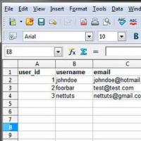 SQL query language Ready-made sql queries
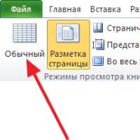 Removing headers and footers in Microsoft Excel
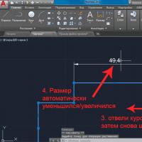 Dimension Styles in AutoCAD AutoCAD Dimension Style Manager
 Internet service e-textbook
 How to create a layer in AutoCAD?