"Volga-Caspian Sea Navigation Canal" (research project). International Journal of Applied and Basic Research Volgo-Caspian Shipping Canal Main Bank
Bakhtemir of the Volga delta with the northern part of the Caspian Sea and crossing the shallow estuarine coast. Allows sea vessels to enter the ports of Olya (Bakhtemir river) and Astrakhan (Volga river). Its total length, including the channel and sea parts, is 188 km.
The need to build this unique and largest hydrotechnical facility, which later connected the internal ports of Russia with the ports of the Caspian Sea, arose in the middle of the 19th century. It was a time of rapid growth in the tonnage of the Russian merchant fleet and the total volume of sea freight. Initially, two independent directions of the future waterway from the Volga to the sea were considered: Kamyzyak and Bakhtemir.
In 1874, the Bakhtemir branch was approved as the most suitable for maritime navigation, the construction of the canal began, the first stage of which lasted 17 years. At the same time, up to 60 thousand m 3 of bottom soil was extracted from the Bakhtemir branch annually. Along the way, from Astrakhan to the very seaside, the waterway was lined with navigation signs. By 1891, the annual cargo turnover through the port of Astrakhan had increased to 146 million poods (2 million 336 thousand tons).
In 1914, the dimensions of the canal were: depth 12 feet (3.6 m), width - 60 fathoms (128 m), length of the navigable slot - 33.2 km.
In the 1930s–1940s in connection with the beginning of the decline in the level of the Caspian Sea, the volume of dredging increased to 10 million m 3 / year.
During the Great Patriotic War, the Volga-Caspian Canal was the only uninterruptedly operating "water bridge" connecting the oil-bearing regions of Transcaucasia with the European part of the country. Despite the constant raids by German aviation, fuel and lubricants, food, equipment and weapons were delivered to the front and rear in a timely manner.
In the first post-war decade, when the level of the Caspian Sea was continuously lowering, the volume of excavated soil increased annually. In 1955, the dimensions of the canal were: depth 3.6 m, width 120 m, length 168 km.
In 1970, the cargo turnover through the canal reached 20 million tons per year. In the early 1990s, with the collapse of economic ties within the country, the volume of cargo transportation through the Volga-Caspian Canal and, accordingly, the volume of dredging operations decreased sharply. In 1995–1998, in connection with the relative stabilization of the level of the Caspian Sea, the volume of cargo transportation was resumed and gradually increased, and, as a result, dredging, which reached 1.8 million m 3 in 1997. Since 1998, merchant shipping has been actively developing in the basin of the Lower Volga and the Caspian Sea. Russia and the Caspian countries joined the North-South international transport corridor, which made it possible to annually increase cargo turnover through the ports of Astrakhan and Olya: from 0.97 million tons in 1998 to 4.7 million tons in 2004. With the growth of maritime trade the volume of dredging works also increased significantly: in 2003 they amounted to 2.54 million m 3 . In 2003, the Volga-Caspian Canal was transferred to the management of the FSUE “Rosmorport” branch in Astrakhan.
Today, the dimensions of the Volga-Caspian Canal ensure the safe movement of ships with a draft of 4.5 m from the sea to Astrakhan and 4.7 m to the port of Olya. New water-gauging posts have been opened, navigation aids for shipping have been modernized, facilities, navigation systems, communications and vessel traffic control systems (NAVTEX and GLONASS) are being put into operation. Two powerful icebreakers provide winter assistance for ships.
Every year, after the passage of the spring flood, some sections of the Volga-Caspian shipping canal are silted up, which leads to a decrease in the depth of the waterway from the guaranteed 4.5 m to 4 and even 3.5 m; this makes it difficult for ships to pass.
At present, up to 12,000 ships pass through the Volga-Caspian shipping channel every year.
D.V. Kozlov. K.D. Kozlov
Municipal budgetary educational institution
"Ninovskaya basic comprehensive school"
Theme "Volga-Caspian Sea Shipping Canal"
(Research work on local history)
Completed:
Kabdrakhimov Timur (grade 9),
MBOU "Ninovskaya OOSh"
Ikryaninsky district
Checked:
Savchenko Elena Nikolaevna
(teacher of geography and biology)
Theme "Volga-Caspian Sea Shipping Canal."
Target:
1. Get acquainted with the history of the construction of the Volga-Caspian Canal.
Tasks:
1. Get acquainted with the history of the construction of the Volga-Caspian Canal;
2. Identify the need to build a canal for the country;
3. Consider the work of the Volga-Caspian Canal for 100 years and identify its significance.
Project problem
The Volga-Caspian Canal is one of the largest water and artificial canals in the world.
Content.
page
INTRODUCTION 3
HISTORY OF CONSTRUCTION OF THE VOLGA-4-5 CASPIAN MARINE NAVIGATION CANAL
WORK AND DEEPENING OF THE CHANNEL FOR 100 YEARS OF EXISTENCE 5-7.
VOLGA-CASPIAN CANAL IN MODERN TIMES 7
CONCLUSION. 8
LIST OF USED LITERATURE. nine
Introduction
Ten kilometers south of Astrakhan, the Volga is divided into two large branches. One of them - with the name Old Volga - goes to the southeast, and the Volga turns to the west. But her way is short, after three kilometers. near the village of Red Barricades, it ends. The Bakhtemir duct serves as a continuation of the Volga. It is also the beginning of the Volga-Caspian navigable canal. Astrakhan people call him the Main Bank. Here, ships passing downstream say goodbye to the river and enter one of the largest sea channels in the world.
The channel outwardly does not differ from other channels of the delta. Only more often on the shores you can see leading signs, and other ship conditions are more saturated. But the rivermen and sailors floating on it know that the guaranteed depths of the ship's passage are at least six meters. The channel is not wide, and the oncoming tanker passes very close to the shore. It is not easy for captains to navigate such giants in the narrowness of the channel, where the current speed reaches one and a half meters per second. Herring gulls accompany the tanker, now and then slowing down the flight and descending to pick up stunned fry from the water.
The history of the construction of the Volga-Caspian Sea
shipping channel
The need for the construction of this unique facility, which subsequently connected the internal ports of Russia with the ports of the Caspian Sea, arose in the middle of the 19th century. It was a time of rapid growth in the tonnage of the Russian merchant fleet and the total volume of sea freight. Two independent directions were considered: Kamyzyak and Bakhtemir. It took fourteen years to finally, in 1874, one of the Volga branches, Bakhtemir, was approved as the most suitable for maritime navigation.
Bakhtemir is a river in the Astrakhan region of Russia, the westernmost of the branches of the Volga delta.
The length of the river is 125 km. The river originates 18 km below Astrakhan and further separates the branch of the Old Volga to the left. The channel network of the Bakhtemir system is rare, which is associated with the concentration of runoff in the main direction, the continuation of which on the estuarine coast is the Volga-Caspian canal. Bakhtemir is more convenient for navigation than the main branch.
From the Turkic languages, the name Bakhtemir is translated as "iron happiness" or "strike in iron"
1874 - the beginning of the first preparatory work in an experimental mode on the fairway and is considered the year of birth of the Volga-Caspian Sea Navigation Canal (VKMSK) - now one of the largest artificial hydraulic structures not only in Russia, but also in the world. Its total length, including the channel and sea parts, is 188 kilometers. So, then another 17 years were spent on active dredging of the Bakhtemir branch, when up to 60 thousand cubic meters of bottom soil were extracted from it annually. From Astrakhan to the seaside, this waterway was already marked by navigation milestones. Accordingly, the cargo turnover through the port city also increases: from 600 thousand poods in 1873 to 146 million poods in 1891, i.e. up to a third of the goods transported then through the Suez shipping canal.
The work and deepening of the canal over 100 years of existence. By 1914 of the last century, the dimensions of the canal were: depth 12 feet (3.6 meters), width - 60 fathoms (128 meters), length of the navigable slot - 33.2 kilometers. In the 1930s and 1940s, as the level of the Caspian Sea decreased, seafarers increased the volume of dredging to 10 million cubic meters of soil per year, due to which cargo flows not only did not decrease, but also grew steadily. During the Great Patriotic War, thanks to courage and to the heroism of military and civilian sailors and rivermen, port workers and railway workers, the canal remained the only “bridge” connecting the oil-bearing regions of Transcaucasia with the European part of the country. Despite the constant fascist air raids on ship caravans, our fronts and rear regularly received fuel and lubricants, food, equipment and weapons.
In the first military decade, when the level of the Caspian Sea was continuously lowering, the volume of excavated soil increased annually.
In 1955, the dimensions of the VKK were:
depth - 3.6 m
width - 120 m
length - 168 km
In 1970, the cargo turnover reached 20 million tons per year.
In the early 90s of the 20th century, with the collapse of economic ties within the country, the volume of cargo transportation along the Volga-Caspian and, accordingly, the volume of dredging fell sharply. In 1995, the canal came under the jurisdiction of the Maritime Port Authority (MAP) of Astrakhan. At this time, with the stabilization of the level of the Caspian Sea, the volumes of cargo transportation are resumed and gradually increase, and as a result, dredging works, which reached 1.8 million cubic meters in 1997.
Since 1998, merchant shipping has been actively developing in the basin. Russia and the countries of the Caspian Sea have joined the international North-South transport corridor, which makes it possible to annually increase cargo turnover through the ports of Astrakhan and Olya: from 0.97 million tons in 1998 to 4.7 million tons in 2004. With the growth of maritime trade, the volume of dredging has also increased significantly: in 2003, it amounted to 2.54 million cubic meters. In 2003, the Volga-Caspian Canal was transferred to the management of the FSUE "Rosmorport" branch in Astrakhan
The Volga-Caspian Canal in modern times. As the level of the Caspian Sea decreased or, conversely, increased, the volumes of dredging and repair and restoration work on the canal also changed. However, the safety of navigation in any, even the most difficult times, has been and remains the main thing for the specialists of the FSUE “Rosmorport” branch in Astrakhan. It is no coincidence that the canal is considered one of the strategically important objects of the Russian economy - one of the branches of the international transport corridor "North-South" passes through it. The development of the resource base of the Caspian Sea, the expansion of the port capacities of Astrakhan, the development of the commercial sea port of Olya - all this is realistically feasible only if the channel functions stably. Surveying, dredging and service work is carried out here with the help of modern technology, which ensures the safe movement of ships with a draft of up to 4.5 meters. Astrakhan sea raid. Today, the special pride of seaport workers is the vessel traffic control system (VTS), which allows the operator to literally “lead” several motor ships at the same time, located tens of kilometers from him. Each of them moves along the channel for an average of 12 to 15 hours, and all this time their location is recorded on computer screens. With the introduction of base stations on about. The nameless canal and in the port of Olya and the sea roadstead will be completely under the control of the VTS, thanks to which for the second year in a row not a single serious accident has occurred in its coverage area. Despite the crisis that has engulfed almost all sectors of the domestic economy, the cargo turnover through the ports of Astrakhan and Olya for 8 months of this year, compared to the same period last year, even increased to 113%, and cargo handling - up to 106%. The number of calls of foreign vessels increased by 18%. All this is the result, among other things, of the competent operation of the “road to the sea”. The staff of the FSUE “Rosmorport” branch congratulates veterans of the industry, fleet workers, all participants in the transport process on the 135th anniversary of the Volga-Caspian Sea Shipping Canal, which works for the benefit of Russia, the great maritime power.
Conclusion.
The canal, as a transport highway, has existed for more than a hundred years. Transportation through the canal is about 10 million tons of various cargoes per year. Their volumes are growing, vehicles are becoming larger, and the depths do not always fully satisfy the needs of the fleet. Many problems arise, they are solved and will be solved in order for the channel to continue to exist.
Bibliography.
Samoilov I. V. Mouths of the rivers of the USSR: Caspian Sea: Volga // Mouths of the rivers / I. V. Samoilov; Rep. ed. corresponding member Academy of Pedagogical Sciences of the RSFSR A. I. Solovyov; Map editor G. N. Malchevsky; Cover by artist A. A. Stolyarov. - M.: Geografgiz, 1952. - S. 183-203. - 528 p. - 5,000 copies. (in trans.)
Semyonov B. A. The Volga Delta. - M.: Physical culture and sport, 1966. - 72 p. - (In native spaces). (reg.)
Rusanov G.M. . Delta, Nizhne-Volga book publishing house. 1990
Sites:
http://www.intast.ru/priem/delta.shtmlhttp://www.volgaflot.com/index.phtml?l=ruHYPERLINK "http://www.volgaflot.com/index.phtml?l=ru&s= 4&url=4313%2804%29.html"&HYPERLINK "http://www.volgaflot.com/index.phtml?l=en&s=4&url=4313%2804%29.html"s=4HYPERLINK "http://www. volgaflot.com/index.phtml?l=ru&s=4&url=4313%2804%29.html"&HYPERLINK "http://www.volgaflot.com/index.phtml?l=ru&s=4&url=4313%2804%29. html"url=4313%2804%29.htmlhttps://ru.wikipedia.org/wiki/Volga-Caspian_channel#.D0.98.D1https://ru.wikipedia.org/wiki/File:VolgaDelta_AMO_2005jun11.j
But! It was proposed to dig the dig back in the seventies, and fill up the Kerch Strait by blocking it with a dam!)
Source: "Technique-Youth No. 11, 1977)
If the project to build the Azov-Caspian Canal had been implemented with a dam in the strait, the Kerch transport crossing would not have been built now.)
What was discovered next perfectly complements the theme of the New Silk Road.
Pay attention to the construction of the sentence -
"... the northern coast of Crimea and the southern coast of Ukraine ..." is clear evidence that in those years, Crimea was not considered part of Ukraine, although the Crimean region was already part of the Ukrainian SSR.
Years passed ... The Great Power - the USSR - did not become, and the unworthy defenders of the green world sounded the alarm: " The construction of the Caspian-Azov canal threatens with a catastrophe! "
As it turned out, the project is very relevant today: “The Southern Scientific Center of the Russian Academy of Sciences, as well as the Hydrotechexpertiza expert center and the Transport Projects Fund at the International Congress of Industrialists and Entrepreneurs came up with the idea of a new “project of the century”. As a REGNUM correspondent was told in The environmental watch in the North Caucasus is proposed to build the Caspian-Azov shipping canal (another name for this project is the "Eurasia Canal"). This canal is supposed to be dug from the Caspian Sea to the mouth of the Don River through the Kumo-Manych Depression. The canal is 650 kilometers long, 70 meters wide, and 16 meters deep..."
Bekturganov N.S., Bolaev A.V. "Prospects and ways of implementing the project for the construction of the Eurasia Canal:" When assessing the possible parameters of the Eurasia Canal, the scientific community proposes the use of river-sea class vessels with a carrying capacity of 10 thousand tons, the use of vessels close to the Seaway Max class with a carrying capacity about 28.5 thousand tons (this type of vessels is used on the St. Lawrence Sea Route in North America), the use of new vessels specially designed for the Eurasia Canal with a carrying capacity of up to 50 thousand tons. tons will be about 5 meters, the draft of Seaway Max class ships is 7.9-8 meters. It is noted that the parameters of ships on the Eurasia Canal will directly affect the efficiency of navigation throughout the Caspian Sea.
| Volga-Caspian Sea Shipping Canal (VKMSK) | |
| Location | |
| The country | Russia |
| Region | Astrakhan region |
| Characteristic | |
| Length | 188 km |
| Max Depth | 6.1 m |
| watercourse | |
| entrance | Bakhtemir (river) |
| mouth | Caspian Sea |
Coordinates : 45°50' N. sh. 47°45′ E d. / 45.833333° N sh. 47.75° E d.(G)(O)45.833333 , 47.75 Volga-Caspian Shipping Canal (WCC) - a channel connecting the deep-water section of the Bakhtemir River (one of the branches in the Volga delta) and the deep-water part of the Caspian Sea through the shallow part of the Volga delta. Allows sea vessels to enter the ports of Olya (Bakhtemir River) and Astrakhan (Volga River).
Construction history
In the middle of the 19th century, a significant increase in the tonnage of the merchant fleet and the volume of maritime cargo transportation began throughout the world and in Russia. In this regard, it became necessary to build a canal linking inland Russian ports with the ports of the Caspian Sea. Initially, two directions of the future road to the sea were considered: Kamyzyak and Bakhtemir. In 1874, the Bakhtemir branch was approved as the most suitable for maritime navigation. This year is considered the year of birth of the WCC. In the same year, the construction of the canal began, the first stage of which lasted 17 years. At the same time, up to 60 thousand cubic meters of bottom soil were extracted from the Bakhtemir branch annually. Along the way, from Astrakhan to the very seaside, this waterway was lined with navigation milestones. In 1891, the cargo turnover through the port of Astrakhan increased to 146 million poods (one third of all cargo transported through the Suez Canal).
In 1914, the dimensions of the VKK were:
- depth - 3.6 m
- width - 128 m
- length - 33.2 km
In the 30-40s of the XX century, due to the drop in the level of the Caspian Sea, the volume of dredging increased to 10 million cubic meters per year. During the Great Patriotic War, the VKK was the only uninterruptedly operating "bridge" connecting the oil-bearing regions of Transcaucasia with the European part of the country. Despite the constant air raids by German aircraft, fuel and lubricants, food, equipment and weapons were delivered to the front and rear in a timely manner. In the first military decade, when the level of the Caspian Sea was continuously lowering, the volume of excavated soil increased annually.
In 1955, the dimensions of the VKK were:
- depth - 3.6 m
- width - 120 m
- length - 168 km
In 1970, the cargo turnover reached 20 million tons per year.
In the early 90s of the 20th century, with the collapse of economic ties within the country, the volume of cargo transportation along the Volga-Caspian and, accordingly, the volume of dredging fell sharply. In 1995, the canal came under the jurisdiction of the Maritime Port Authority (MAP) of Astrakhan. At this time, with the stabilization of the level of the Caspian Sea, the volumes of cargo transportation are resumed and gradually increase, and as a result, dredging works, which reached 1.8 million cubic meters in 1997.
Since 1998, merchant shipping has been actively developing in the basin. Russia and the countries of the Caspian Sea have joined the international transport corridor "North-South", which makes it possible to annually increase cargo turnover through the ports of Astrakhan and Olya: from 0.97 million tons in 1998 to 4.7 million tons in 2004. With the growth of maritime trade, the volume of dredging has also increased significantly: in 2003, it amounted to 2.54 million cubic meters. In 2003, the Volga-Caspian Canal was transferred to the management of the FSUE “Rosmorport” branch in Astrakhan.
Today, the dimensions of the canal ensure the safe movement of ships with a draft of 4.5 meters to Astrakhan and 4.7 meters to the port of Olya. Water-measuring posts have been created, navigation aids are being upgraded, GMSS facilities in sea areas A-1 and A-2, navigation, communication and ship traffic control systems (NAVTEX and GLONAS) are being put into operation. Two powerful icebreakers provide winter assistance for ships. All this made it possible to increase the level of safety of navigation along the canal and the Caspian Sea.
Made this comment:
Somehow I wanted to go fishing in the Volga delta and began to look at the satellite map and saw some channels in the delta that go to the sea, and they go without taking into account the current delta and the nature of the river and go far on land. I got interested, found that yes, there is such a channel - the Volga Caspian for the passage of ships at sea. But there are many channels! not one!, looked at the Ural delta even more trenchantly, a lot of channels, but I didn’t find a word anywhere that someone would once dug them! Moreover, at present, the Urals are, as it were, not navigable, and especially they have never been like that! began to consider the deltas of the main rivers - many have channels that are not reflected in history. Venice is very interesting - you can see a lot of things under water - canals, quarters.
The topic of channels inspired me so much that I could not pass by this information. Moreover, the scale of these ancient (and not so) hydraulic structures is fantastically voluminous almost all over the world, and I hope there will be articles on this topic in the future (as time permits).
So, the Volga delta. The Volga Delta is the largest river delta in Europe and one of the largest in the world. Its area is about 19 thousand square kilometers, in the Volga delta, according to various sources, there are from 500 to 850 watercourses.
The mouth of the Volga is a lot of channels, forks, which are simply lost in the swampy soils. In this photo, by the way, some canals crossing the ducts are visible.


The mouth of the Volga. Coordinates: 46° 3" 12.02" N 48° 58" 26.88" E. Map Link
The photo of this place is in the title of the post.

The channel goes to the Caspian Sea

Its width is about 50m

A little to the west, here is such a short channel to a rectangularly dug water fence. Link to place

To the east is a network of intersecting channels. Link to place


Another short canal with a rectangular water fence
Going west:
Volodarsky district, near the village of Tishkovo. Map Link

It can be seen that the channel crosses the ducts, i.e. it is impossible to attribute it to adaptation, clearing, dredging of existing channels. This is the dug channel
45° 55" 30.45" N 48° 34" 48.61" E
45° 43" 18.56" N 48° 27" 52.71" E
45° 49" 1.47" N 48° 24" 46.70" E
45° 41" 32.04" N 48° 13" 43.68" E

Converging channel system
This is a narrower channel - a branch from the main channel. Map Link

There are channels that are hidden under water in some parts, but if you draw a line from where it ends to where it starts on the other side, the line will be straight. Here is an example of such a continuation. Map Link

Even further west

As you understand, this network cannot be natural channels. Map Link
But if you look at the official map of the Volga delta, you will see little:
No, some are marked, but almost like a natural channel or channels (clickable)
This is a satellite image of the Volga delta. It shows many channels.

The most famous and official hydraulic structure in the Volga Delta is the Volga-Caspian Canal. Width over 250m
The Volga-Caspian Shipping Canal (VCC) is a canal connecting the deep-water section of the Bakhtemir River (one of the branches in the Volga delta) and the deep-water part of the Caspian Sea through the shallow part of the Volga delta. Allows sea vessels to enter the ports of Olya (Bakhtemir River) and Astrakhan.
Initially, two directions of the future road to the sea were considered: Kamyzyak and Bakhtemir. In 1874, the Bakhtemir branch was approved as the most suitable for maritime navigation. This year is considered the year of birth of the WCC. In the same year, the construction of the canal began, the first stage of which lasted 17 years. At the same time, up to 60 thousand cubic meters of bottom soil were extracted from the Bakhtemir branch annually. Along the way, from Astrakhan to the seaside, this waterway was lined with navigation milestones. In 1891, the cargo turnover through the port of Astrakhan increased to 146 million poods (one third of all cargo transported through the Suez Canal).
In 1914, the dimensions of the VKK were:
depth - 3.6 m
width - 128 m
length - 33.2 km
In the 30-40s of the XX century, due to the drop in the level of the Caspian Sea, the volume of dredging increased to 10 million cubic meters per year.
In 1955, the dimensions of the VKK were:
depth - 3.6 m
width - 120 m
length - 168 km
In 1970, the cargo turnover reached 20 million tons per year. With the growth of maritime trade, the volume of dredging has also increased significantly: in 2003, it amounted to 2.54 million cubic meters. Today, the dimensions of the canal ensure the safe movement of ships with a draft of 4.5 meters to Astrakhan and 4.7 meters to the port of Olya. There are no gateways.
Map Link
Canal in winter
But there is no information about this entire network of canals connecting the rest of the Volga with the Caspian. Although there is still something. Many of these channels have names:
- "New channel" - Igolkinsky Canal. Was dug in the 1950s
- Obzhorovsky Canal
- Karsky and Vasilyevsky channels
- Tishkovsky Canal (dug in the Caspian - deepening the bottom)
- Chupinsky channel
- South Canal
- Khorevskaya furrow - Gandurinsky canal
- Lower Moryannaya furrow - near the confluence of the Gandurinsky and Nikitinsky channels
- Middle Moryannaya Furrow - Gandurinsky Canal
- Kirov Canal (dug in the Caspian - deepening the bottom)
- Kolochny canal
- Staro-Nikitinsky canal
- Karai channel (fish passage)
- Rychansky canal (fish passage)
- Kulaginsky channel (dug in the Caspian Sea - deepening the bottom)
- Bardyninsky channel (dug in the Caspian Sea - deepening the bottom)
- Belinsky Canal (partially dug in the Caspian - deepening the bottom)
Some of these channels are listed here in this document.
Which where - is partially known. You can scroll through the map with the channels shown on it
The government of the Astrakhan region, of course, has more detailed information. In some places, these channels are called channels-fish passages. Yeah, almost navigable channels up to several tens of meters wide were dug for fish to travel during spawning.

I know that many are interested in what kind of “striped” formations are from the left and right banks of the Volga Delta. They look like ancient huge dunes. But why they have such an orientation and the mechanism of their formation is not clear.
Let's move on to another canal system in the Caspian: let's look at the Ural-Caspian canal (delta of the Ural River):
46° 51" 13.87" N 51° 34" 2.72" E. Map Link
Even Wikipedia doesn't know about it. When it was dug is unknown. I can guess that in the middle of the 20th century.
The section of the Ural River from the city of Atyrau to the sea is the Ural-Caspian shipping channel with a length of 56 kilometers. The mouth of the river has become so shallow that in the area where it enters the Caspian Sea, the depth of the canal is about ... one meter! And sometimes even less...

Near the delta there are other, most likely, irrigation canals. Now they are in disrepair, but in Soviet times they were in demand. Having looked in Google maps, it is clear that the channels are not so straightforward, in some places you can see how they meander. Those. built them without any precision.
It is possible that all these canals were built in the late 19th century. to the middle of the 20th century But it is not always possible to drive a dredging vessel or a barge with a backhoe. I do not exclude the version that many of the created rectilinear ducts existed long before that. On old maps, the Caspian has a completely different outline. They write that Baku was not a port city at all before. Maybe the Volga delta was more plow, and the Volga more full-flowing. And it made sense to build these canals for the purpose of, say, land reclamation, as in Vietnam.
 Consider each of the requirements for metal detectors
 Metal detector in an educational institution
 How to wipe the TV screen at home
 Senaki mikha tskhakaya. Mikha tskhakaya. Notable residents of the city
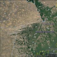 International Journal of Applied and Basic Research Volgo-Caspian Shipping Canal Main Bank
 How to deal with sunburn if you are burned
 Hagen, Germany: why go, what to do, where to eat, travel tips Where and what to eat and drink in Hagen